
Frequently Asked Questions
Below are some commonly asked questions about this project. If you have any other enquiries, please contact Council at future@hornsby.nsw.gov.au.
A Local Strategic Planning Statement (LSPS) is a document that will set out a 20-year vision for land-use in the local area, the special character and values that are to be preserved, shared community values and how council will manage growth and change.
The LSPS will be drafted in Plain English and include maps, images and other visual aids wherever possible. It will be designed to be easily read by anyone in the community wanting to understand:
- Areas that may change in the future;
- Areas of special character and importance to the community;
- Planning priorities for the Local Government Area;
- Issues of particular value and how they will be addressed in council’s land use plans.
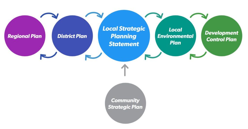
Council will use the LSPS to provide consistent strategic reasoning when:
- Explaining the land use requirements to the community;
- Justifying the decision of a development application;
- Providing expert advice at the Land and Environment Court;
- Council wants to review its strategic direction.
Frequently Asked Questions
Below are some commonly asked questions about this project. If you have any other enquiries, please contact Council at future@hornsby.nsw.gov.au.
If you have further information you would like to contribute (images, more detailed text), please email them directly to us at projects@extent.com.au.
Please note that submissions closed on Wednesday, 31 March 2021.
The scope of the Aboriginal Heritage Study is based on the Gap Analysis and Action Plan, that was prepared for Council in 2019. The key objectives are:
- To update data on Aboriginal heritage sites and places, and provide an improved understanding of the condition of these places.
- To broaden the recognition of Aboriginal heritage beyond pre-colonisation archaeological sites.
- To identify mechanisms for ongoing consultation and collaboration with local Aboriginal people about the management of their heritage.
The Aboriginal Heritage Study will include a review of the Aboriginal archaeology and history of the Shire, and will identify places, people and themes of heritage significance. The Study will provide policies and recommendations to assist Council with their responsibility to manage Aboriginal heritage within the Shire. Importantly, the study will also include consultation with Aboriginal people with traditional and historical ties to the Shire, and recommendations for ongoing involvement of Aboriginal people in the management of their heritage.
Following the public exhibition, a report on the submissions received will be presented to Council with a recommendation for endorsement or amendment taking into consideration the feedback received.
Once adopted by Council, the Hornsby Thematic History would be used to inform the subsequent projects under the Comprehensive Heritage Study identified in the Hornsby Heritage Action Plan in order to meet its commitment to the conservation and promotion of natural and cultural heritage through updating Council’s heritage management policies.
The draft Hornsby Thematic History was prepared by GML Heritage with the following team members:
Sharon Veale
Sharon is Chief Executive Officer and Partner, would be GML’s project director for this project. Sharon is a public historian and urban planner with over 20 years’ experience in Aboriginal and historical cultural heritage assessments, management and conservation for public and private sector clients. Sharon would oversee the successful delivery of the project and provide historical and project management advice.
Sharon is known for her strategic and creative thinking. She has extensive experience in the delivery of independent advice for complex heritage places and planning matters, and is well recognized for award-winning interpretation from concept to implementation, led by design thinking, public history, and people’s stories and memories.
Léonie Masson
Léonie is a historian with over 20 years’ experience. She has prepared site histories, significance assessments and site descriptions for a broad range of reports for private, institutional and local, state and Commonwealth government clients, including conservation/heritage management plans, statements of heritage impact, heritage assessments, and heritage interpretation plans and strategies. Her work has spanned a diverse array of sites in NSW, Queensland, Victoria and South Australia, from residential and education projects to rural grain silos to inner-city heritage conservation areas.
Prior to joining GML, Léonie worked in heritage consultancies, as a freelance historian and as a senior historical services librarian.
Minna Muhlen-Schulte
GML Senior Heritage Consultant and Historian, would develop the thematic history and research as project manager to this project. As a professional historian and project manager, Minna has developed substantial experience in consulting environments leading research, building interpretive frameworks and community engagement projects for government and private clients in NSW and Victoria. Minna would support and help organise the consultation phase, and liaison with stakeholders. She will identify research to be reviewed and arrange access to collections held at local studies. Minna prepare the draft and final Thematic History.
The Thematic History does not identify specific areas, places, periods, structures or sites for the inclusion in Council’s heritage schedule. The project is intended to set up the framework for the subsequent heritage studies.
The project objectives are:
- To prepare a new thematic history to reflect the course and pattern of Aboriginal occupation, land use and the development of Hornsby Shire as it exists today.
- To specifically include Aboriginal occupation, history and heritage, landscape heritage, the impact of post war and modern (post- 1960) development and all other relevant aspects of environmental heritage.
- To examine, identify and characterise what is unique about Hornsby Shire in a thematic context.
- To create specific local themes relevant to contemporary communities, that have regard to the 36 NSW State Themes.
- To explain the major factors that have influenced the history and heritage of Hornsby Shire and shaped its distinctive character in an engaging, contemporary and usable format.
- To provide a thematic history that can ensure the historical development and unique character of Hornsby can be reflected in Council’s subsequent studies to be completed under the Comprehensive Heritage Study program timeline and Action Plan 2019.
A thematic history provides a broad historical context for understanding the patterns and forces that shaped an area over time. It identifies locally distinctive themes to structure the history. A theme can unite a variety of actions, events, functions, people and dates, it helps to prevent any concentration on a particular type of item, period or event of history.
The thematic history is not intended to be a detailed account of all aspects of the history of an area, nor to replace histories designed to serve other purposes.
The development of the thematic history will align with the 36 New South Wales Historical Themes as defined by Heritage NSW. However as noted by Heritage NSW ‘Not all themes are relevant throughout the state…[and] local themes will not necessarily fit neatly into the state thematic framework.’
In 2018 Council made a commitment to undertake a Comprehensive Heritage Study to respond to the changing development context, demography and community expectations regarding the identification, policy and protection of Hornsby Shire’s heritage.
The Hornsby Heritage Action Plan was prepared in 2019 to identify the strategic tasks required to guide the scope of the Comprehensive Heritage Study. A four-year programme to complete the tasks was subsequently endorsed by Council in April 2020.
Year 1 of the programme commenced in October 2020 with the preparation and update of four key background studies:
- Hornsby Thematic History
- Aboriginal Heritage Study
- Archaeological Heritage Study
- Landscape Heritage Study
The preparation of each study will be undertaken with input from the Hornsby Council Heritage Advisory Committee (HAC), and the Hornsby Aboriginal & Torres Strait Islander Consultative Committee (HATSICC) throughout the course of the projects.
The Landscape Heritage Study is projected to be completed by late-2021.
The Landscape Heritage Study is being led by Extent Heritage and 33 Parallel Landscape Architects. The project team is comprised of the following personnel:
Eleanor Banaag, Senior Associate
Eleanor has worked in the heritage industry for over fifteen years and is highly skilled in heritage interpretation development, materials and built heritage conservation, heritage impact and planning control assessment and collection management. Eleanor has been involved in State significant urban developments, providing construction heritage management advice, impact assessment and materials conservation recommendations. Eleanor was critically involved in undertaking the Cumberland Council Heritage Review, which involved the reassessment of approximately 350 individual heritage items and HCAs, and the assessment of over 150 potential new heritage items. She also prepared a maintenance and repair guidelines for Council-owned heritage assets for Wingecarribee Shire Council.
Eleanor will project manage the delivery of the Landscape Heritage Study.
Kim Watson, Heritage Advisor
Kim is a heritage advisor with a background on working on various built heritage projects in NSW. She has a Masters degree in Heritage Conservation from the University of Sydney and has worked in the industry for over four years. During her career, Kim has been a part of several large-scale projects within NSW including sites of local and state heritage significance. She has developed a wide range of skills in historical research, heritage impact assessments and field survey. She has experience in producing Photographic Archival Recordings, Statements of Heritage Impacts, Conservation Management Plans, Moveable Heritage Audits and Heritage Studies. She has worked on several large multi phased projects such as the Sydney Trains Signal Box Movable Schedules, Mount Victoria Conservation Management Plan, Cumberland Council Heritage Study, and Randwick Heritage Study.
Kim is working on all phases of the Landscape Heritage Study.
Darren Mansfield, 33 Parallel Landscape Architects
Darren’s experience as a Landscape Architect covers a wide range of projects from landscape scenic assessments through to major road and rail infrastructure, airports, embassies, campuses, parks and resorts. He has directed the planning and design of significant public and private landscapes locally, nationally and internationally and brings a deep technical understanding, design experience and leadership to projects.
He brings a strong sustainability ethic to his work including those with water sensitive urban design components and has co-authored the Roads and Maritime Service’s Water Sensitive Urban Design Guidelines. He is also the author of a book on Australian rainforest plants. His experience covers all aspects of project delivery from concept design to drawing and specification coordination, consultant coordination, programming, design and material selection, production drawings, reports, and construction administration.
Darren is working on all phases of the Landscape Heritage Study.
Yes – this Landscape Heritage Study will identify potential items for listing. The project team will carefully assess historical maps, plans and aerials to identify areas of potential cultural significance. The potential items will also be informed by a gap analysis of previous studies and targeted fieldwork.
If you have knowledge that you would like to contribute, please email our project team at fenella@coasthistory.com.au Or phone 1800 450 995.
We are seeking any information that you may like to share about the Aboriginal history of the Shire, and particular places of importance, and your thoughts on how Council can recognise and protect this rich heritage
Once a draft of the Aboriginal Heritage Study has been completed, the study will be placed on public exhibition for review and comment.
The purpose of this comprehensive review and development of an updated Landscape Heritage Study is to:
- Prepare a new comprehensive Landscape Heritage Study that captures all cultural and natural landscapes that have heritage significance for listing on Schedule 5 of the Hornsby Local Environmental Plan,
- A comprehensive review and consolidation of the previous landscape and heritage studies, as well as background material where necessary, including primary and secondary source material, libraries and historical collections, comprising of written records, maps, photos, local histories and other documents and backgrounds relating to the landscape and natural heritage of Hornsby.
- Review of all previously identified landscape heritage items and landscape components of heritage items and reassess significance.
- Identify any potential new cultural or natural landscape items.
- Provide updated inventory sheets and provide increased accuracy and detail.
- Provide information necessary for Council to meet its statutory obligations and management policies for the maintenance and protection of landscape heritage.
- The updated data and information are presented in an engaging, contemporary and usable format.
- Provide Council with recommendations for future management and planning.
The Landscape Heritage Study is a review of all natural and cultural landscape items listed on Schedule 5 of the Hornsby LEP, excluding National Parks. The Landscape Heritage Study intends to capture all cultural and natural landscapes and attributes that have heritage significance for listing in the Hornsby LEP and to provide greater detail and clarity around the landscape heritage of Hornsby Shire, as it exists today.
There are three broad categories, that are based on the World Heritage guidelines for cultural landscape types, that are applied to assess culturally significant landscapes. They offer a useful starting point for understanding landscapes.
- Designed landscapes are created intentionally. They include garden and parkland landscapes constructed for aesthetic reasons, such as trees, avenues, parks, gardens, cemeteries and plazas.
- Organically evolved or ‘vernacular’ landscapes have developed over time in response to, and association with the natural environment. Organically evolved landscapes often develop through changes brought about by patterns of use. They fall into two sub-categories: a relict landscape where an evolutionary process has ended; and a continuing landscape where the evolutionary process is still in progress. Organically evolved landscapes include farming landscapes, industrial landscapes such as goldfields, and linear landscapes such as railway lines.
- Associative landscapes are primarily based on religious, spiritual, artistic or cultural associations with the natural environment. Associative landscapes are often significant for their intangible, non-physical values associated with events, activities or significant people. They include landscapes such as explorers’ routes, Aboriginal places and river crossings or places where celebrations have occurred. They also include landscapes that have stories told about them. Documents and oral histories relating to what happened at the place are especially important in identifying and assessing how people interacted with these types of landscapes.
The Archaeological Heritage Study is programmed for completion by mid-2021.
The Archaeological Heritage Study is being led by Extent Heritage. The project team is comprised of the following personnel:
Dr Jennifer Jones-Travers
Jennifer has over 16 years’ experience as a heritage practitioner, has worked as an archaeologist in consulting, government, and academic contexts and is a current member of the Tasmanian Heritage Council. She holds a PhD with a specialisation in Australian historical archaeology. Jennifer is skilled in preparing reports in support of all phases of archaeological investigations, including the assessment of archaeological potential and significance, research design, and post-excavation reporting. Jennifer is leading the project for Extent and providing technical input into all deliverables.
Graham Wilson
Graham is a highly experienced historical archaeologist with a wide range of excavation and survey experience, both in Australia and overseas. Graham has conducted a large number of assessments and excavations for a variety of clients, including small site owners, major development/construction companies, and state and Commonwealth government departments. He has worked on major state-significant historic sites, such as the convict sites of Port Arthur, Norfolk Island and Parramatta as well as a number of sites of local significance across regional NSW (eg: Ballina, Bega, Merimbula, Mullengandra, Tarcutta, etc). Graham is recognised by Heritage NSW, as an approved Excavation Director for both local and state significant sites in NSW; he has directed a number of local and state heritage–listed sites in Victoria and WA. Graham is providing specialist input into the Archaeological Heritage Study, including the identification of new sites and management recommendations.
Francesca McMaster
Francesca McMaster is a heritage advisor with a background working on various historical archaeological projects in NSW. She has an honours degree from the University of Sydney in Australian Archaeology and has worked in the industry for over three years. During her career, Francesca has been part of several large-scale projects within NSW, including sites of State and national heritage significance (Mt Victoria Train Station, Barangaroo, Robin Thomas Reserve, Parramatta, etc). Francesca has also been involved in preparing various heritage and impact assessments and reporting on archaeological excavations, including post-excavation data management. Francesca is working on all phases of the Archaeological Heritage Study.
Yes—the project team is carefully assessing historical maps, plans and aerials to identify areas likely to contain significant historical archaeological sites that might be considered for listing. To be listed, the sites must have the potential for archaeological ‘relics’, as defined by the Heritage Act 1977 (NSW) (the Heritage Act).
Archaeological relics are afforded blanket protection under the provisions of the Heritage Act (Sections 139 through 146). Listing of identified archaeological sites will not change this protection but will reduce the uncertainty and delays associated with unexpected archaeological finds. Prior identification of archaeological sites will ensure that they are appropriately managed in the development process.
If you have further information you would like to contribute (images, more detailed text), please email them directly to us at projects@extent.com.au.
Please note that submissions closed on Wednesday, 31 March 2021.
The objectives of the Archaeological Heritage Study are to:
- Review currently listed archaeological sites and confirm if the listings are still relevant;
- Identify new archaeological sites through the assessment of historical studies, aerials, and maps, as well as consultation with the local community;
- Assess the current condition of select archaeological sites;
- Develop an inventory sheet for every archaeological site included in the study;
- Complete digital mapping to provide site locations to Council; and
- Make recommendations to ensure the appropriate management of significant archaeological sites, including input into the next Hornsby Local Environmental Plan (LEP) and Development Control Plan (DCP).
An Archaeological Heritage Study looks at a broad area and considers its potential for historical archaeological sites, as well as their likely levels of significance, with identified sites being considered for listing in the next version of the Hornsby Shire Local Environmental Plan (LEP). It also provides clear policies and recommendations to ensure that significant archaeological remains are identified and appropriately managed during the development process.
While it may not capture every archaeological site across the Shire, it will try to locate and map the earliest sites and those identified as being most significant by the local community. This is where we need the community’s assistance to understand what is most important to local residents and why.
A thematic history provides a broad historical context for understanding the patterns and forces that shaped an area over time. It identifies locally distinctive themes to structure the history. A theme can unite a variety of actions, events, functions, people and dates, it helps to prevent any concentration on a particular type of item, period or event of history.
The thematic history is not intended to be a detailed account of all aspects of the history of an area, nor to replace histories designed to serve other purposes.
The development of the thematic history will align with the 36 New South Wales Historical Themes as defined by Heritage NSW. However as noted by HNSW ‘Not all themes are relevant throughout the state…[and] local themes will not necessarily fit neatly into the state thematic framework.’
Given the age of the original study, Council is mindful of its need to update the thematic history. The project objectives are:
- To prepare a new thematic history to reflect the course and pattern of Aboriginal occupation, landuse and the development of Hornsby Shire as it exists today.
- To specifically include Aboriginal occupation, history and heritage, landscape heritage, the impact of post war and modern (post- 1960) development and all other relevant aspects of environmental heritage.
- To examine, identify and characterise what is unique about Hornsby Shire in a thematic context.
- To create specific local themes relevant to contemporary communities, that have regard to the 36 NSW State Themes.
- To explain the major factors that have influenced the history and heritage of Hornsby Shire and shaped its distinctive character in an engaging, contemporary and usable format.
- To provide a thematic history that can ensure the historical development and unique character of Hornsby can be reflected in Council’s subsequent studies to be completed under the Comprehensive Heritage Study program timeline and Action Plan 2019.
Community members will be invited to contribute to the new Thematic History via Social Pinpoint a platform that allows users to locate places, share stories and historical material important to the historical development of the Hornsby Shire LGA.
The thematic framework will also be circulated for comment and suggestions on the update of themes.
The project team will also be working closely with the Hornsby Council Heritage Advisory Committee, Hornsby Aboriginal & Torres Strait Islander Committee (HATSICC) throughout the development of the project.
Vision and Principles
The Vision and Principles for the Hornsby Town Centre Review were endorsed by Councillors as part of Council’s Local Strategic Planning Statement.
Preliminary Engagement and Collaboration
The Hornsby Town Centre Review is being undertaken in close collaboration with the Hornsby community, State agencies, and other stakeholders. In the initial stages, consultation included drop-in sessions, community pop-ups, letters, website engagement and a co-design workshop.
Key messages from the community engagement included:
- Balance new development with strong local character and retail and public space experience.
- Provide public spaces and green spaces to reinforce the Shire’s bushland identity.
- Sustainability should be at the core of the Hornsby Town Centre.
- Maximise connectivity and public walkability by reconfiguring the way bus movements occur.
- Recognise and reinforce the role of the Town Centre within Hornsby Shire and Greater Sydney.
- Additional east-west connections across the Station are crucial to realising a coherent and functional Town Centre.
Evidence
Technical investigations to inform the Review and to ensure a robust evidence base for Town Centre Vision include:
- Background Information and Literature Review
- Identifying Issues and Opportunities
- Social and Community Infrastructure Needs Analysis
- Heritage Analysis
- Landscape and Public Domain Improvements
- Economic Development and Employment Land Uses
- Housing and Affordable Housing Analysis
- Traffic and Transport Analysis
- Car Parking Analysis
For enquiries, please contact Hornsby Shire Council’s Strategic Land Use Planning Team on (02) 9847 6726.
A staged approach to implementation of recommendations will be undertaken, split into short and long term actions.
Short term actions:
Council officers will prepare a Planning Proposal to amend the Hornsby Local Environmental Plan 2013 to implement short term actions involving new land uses in rural zones and other general recommendations of the Study.
Once prepared, the Planning Proposal will be reported to Council to seek endorsement to submit to the Department of Planning and Environment for gateway determination. Following the issue of a gateway determination by the Department of Planning and Environment, the Planning Proposal would be publicly exhibited and a report on submissions presented to a Council meeting for consideration. Subject to Council’s endorsement to finalise the Planning Proposal, the Planning Proposal would be submitted to the Department of Planning and Environment for finalisation and implementation into the Hornsby Local Environmental Plan 2013.
Short term actions involving amendments to the Hornsby Development Control Plan 2013 would also be subject to an exhibition period and a report on submissions before Council endorses finalisation.
Long term actions:
Council will consider progression of certain long-term actions involving strategic investigations at an informal Councillor workshop. This will enable Council to give consideration of priorities, resources and funding to undertake the strategic investigations.
The planning report (PC8/22) and meeting minutes from the 8 June 2022 Council meeting can be viewed from the following link businesspapers.hornsby.nsw.gov.au (scroll down to view the Business Paper for 8 June 2022).
A recording of the meeting is available here: hornsby.webcastcloud.com
At its meeting on 8 June 2022, Council endorsed implementation of short term recommendations involving new land uses in rural zones and other general recommendations. These recommendations are set out in Implementation Action Plan A – Short Term Recommendations.
Also at this meeting, Council decided to give further consideration to certain recommendations involving strategic investigations at an informal Councillor workshop. This will enable Council to consider priorities, resources and funding to undertake these projects. These recommendations are set in Implementation Action Plan B – Long-Term Recommendations.
The Hornsby Thematic History will be used to inform the subsequent projects under the Comprehensive Heritage Study identified in the Hornsby Heritage Action Plan in order to meet its commitment to the conservation and promotion of natural and cultural heritage through updating Council’s heritage management policies. It will also establish the foundation of heritage considerations for Hornsby Shire by explaining locally distinctive themes, assisting identification and protection of our local heritage.
The draft Hornsby Thematic History was prepared by GML Heritage with a project team comprised of the Chief Executive Officer and Partner and two professional historians/heritage consultants with over 20 years’ experience in Aboriginal and historical cultural heritage fields.
The Thematic History does not identify specific areas, places, periods, structures or sites for the inclusion in Council’s heritage schedule. The project sets up the framework for the subsequent heritage studies.
The project objectives were:
- To prepare a new thematic history to reflect the course and pattern of Aboriginal occupation, land use and the development of Hornsby Shire as it exists today.
- To specifically include Aboriginal occupation, history and heritage, landscape heritage, the impact of post war and modern (post- 1960) development and all other relevant aspects of environmental heritage.
- To examine, identify and characterise what is unique about Hornsby Shire in a thematic context.
- To create specific local themes relevant to contemporary communities, that have regard to the 36 NSW State Themes.
- To explain the major factors that have influenced the history and heritage of Hornsby Shire and shaped its distinctive character in an engaging, contemporary and usable format.
- To provide a thematic history that can ensure the historical development and unique character of Hornsby can be reflected in Council’s subsequent studies to be completed under the Comprehensive Heritage Study program timeline and Action Plan 2019.
A thematic history provides a broad historical context for understanding the patterns and forces that shaped an area over time. It identifies locally distinctive themes to structure the history. A theme can unite a variety of actions, events, functions, people and dates, it helps to prevent any concentration on a particular type of item, period or event of history.
The thematic history is not intended to be a detailed account of all aspects of the history of an area, nor to replace histories designed to serve other purposes.
The development of the thematic history will align with the 36 New South Wales Historical Themes as defined by Heritage NSW. However as noted by Heritage NSW ‘Not all themes are relevant throughout the state…[and] local themes will not necessarily fit neatly into the state thematic framework.’
Following the local Government elections this year, the new Council will be briefed on the HTC Review and the results of the traffic and transport analysis. Council would then be in a position to endorse the exhibition of the draft concepts to seek community and stakeholder feedback.
To implement any changes to planning controls arising from the HTC Review, a planning proposal would be required to be lodged with the State Government which would also include requirements for public exhibition.
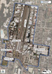
The Hornsby Town Centre study area encompasses both the East and West sides of Hornsby Railway Station. In the east, it includes Westfield Hornsby, Hornsby Mall and the businesses located along George Street up to Bridge Road which forms the northern boundary. In the west, it is bound to the south by Hornsby RSL Club and vacant land in Ashley Street and includes all the businesses on Peats Ferry Road, in William and Dural Streets, up to Bridge Road to the north.
No, the project is intended to set up the framework for the subsequent heritage studies. The Thematic History is not intended to identify specific areas, places, periods, structures or sites for the inclusion in Council’s heritage schedule.
Council has already had the opportunity to address one of the recommendations of the draft Study in response to a change in planning legislation by the State Government enabling councils to nominate a maximum size for secondary dwellings in rural areas.
At its meeting on 14 April 2021, Council resolved to increase the permitted size of secondary dwellings from 60sqm to 120sqm and retain the control that permits secondary dwellings up to 33% of the floor area of the principal dwelling.
These new controls were implemented into the Hornsby LEP in November 2021.
Further information about secondary dwelling controls in Hornsby Shire is available here: https://www.hornsby.nsw.gov.au/property/myproperty/developing-my-property/granny-flats
Following any Council decision on whether to endorse the Rural Lands Study and to implement the recommendations, an action plan will be developed which will set out the order and timing for the many elements in the Study to be addressed. The timing for completion of investigations and subsequent changes to planning controls that Council decides to progress would be staged over several years.
Should Council decide to implement changes to planning controls in the Hornsby Local Environmental Plan 2013, this would require further consultation with the community and approval from the NSW Department of Planning, Industry and Environment.
A Report addressing the feedback from the exhibition of draft Rural Lands Study will be presented to Council at its meeting on 8 June 2022. The planning report is available to read through the following link businesspapers.hornsby.nsw.gov.au/ (scroll down to view the Business Paper for 8 June 2022).
Further information about Council meetings is available at the following link: hornsby.nsw.gov.au/council/about-council/meetings
If you have any further enquiries, please contact the Strategic Land Use Planning Branch on 9847 6729, or for questions about the Meeting arrangements, Council’s Meetings and Governance Officer on 9847 6836.
The draft Rural Lands Strategy includes a basic map of each landscape area. A detailed map of the landscape area boundaries is available on Council’s online mapping tool.
Preliminary Consultation 2019:
In 2019, Council undertook an extensive consultation with the community as part of the preliminary stages of the Study. The purpose of the consultation was to obtain feedback on draft landscape and character statements prepared.
The consultation was promoted through letters to all rural land owners, newspaper advertisements, Council’s e-newsletter, facebook page and website. Consultation activities included face to face workshops in Galston and Glenorie, drop in sessions and an online survey.
The feedback received from the community is outlined in the 2019 Feedback Summary Report and was considered by the consultants in progressing with the Study.
Exhibition of draft Rural Lands Study 2020:
The draft Rural Lands Study was exhibited to the community from mid-September until mid-November 2020. The exhibition was promoted through letters to all rural land owners, newspaper advertisements, Council’s e-newsletter, facebook page and website. Feedback was invited via submissions or an online survey.
The feedback received during the public exhibition period is outlined in the Feedback Summary Report.
An outline of the various stages of the project timing and is provided below:
| Stage | Date | Task |
|---|---|---|
| Stage 1 – Existing Situation | March – August 2019 | Review of background material. |
| Stage 2 – Draft landscape character | August 2019 | Draft Landscape Areas Report prepared, which identified landscape areas and a character statement for each area. |
| Stage 3 – Community feedback | Oct – Dec 2019 | Community consultation to obtain feedback on the draft landscape areas and character statements. 2019 Feedback summary report published on Council’s website. |
| Stage 4 – Review | Jan-July 2020 | Draft Rural Lands Study Background Report prepared. |
| Stage 5 – Findings and Recommendations | Mid 2020 | Draft Rural Lands Strategy prepared. |
| Public Exhibition of draft Rural Lands Study | Sep to Dec 2020 | Exhibition of the draft Rural Lands Strategy and the draft Rural Lands Study Background report. |
| Review | 2021-2022 | Review of submissions and briefing with the new Council. |
| Council meeting | 8 June 2022 | Council resolved to finalise the Study with a staged approach to implementation. |
Council’s current planning framework for the rural areas has been informed by previous studies. Although Council has completed planning control reviews and community surveys in the past, the last comprehensive evidence-based study was completed in 1995. A lot has changed since this time, with new pressures and opportunities emerging.
In 2018, Council commenced a Rural Lands Study to provide a new evidence base and recommendations for managing the rural areas of Hornsby shire into the future. SGS Economics and Planning was engaged by Council to prepare the Study.
The Study is required to align with relevant actions of the State Government’s North District Plan, which includes actions for better managing rural lands.
The project is scheduled to be completed in late 2021.
The Aboriginal heritage study is being completed on behalf of Hornsby Shire Council by Coast History and Heritage. The team includes:
Fenella Atkinson
Fenella is managing the study. She is a heritage consultant with over 20 years’ experience in Aboriginal and historical cultural heritage management, with a focus on archaeology. Most of her work has been in New South Wales, but she also has experience in Western Australia, Queensland, and Victoria. Fenella is engaged in tertiary studies in anthropology. She is currently the joint national coordinator of National Archaeology Week and also coordinates the Student Support Fund for the Australian Association of Consulting Archaeologists Inc.
Dr Michael Bennett
Michael is the project historian. He has worked for the past 20 years in Aboriginal history, preparing expert reports for NSW native title claims, recording community genealogies and writing regional histories for local councils and government authorities. More recently, he has recorded oral histories for the State Library of NSW and National Library of Australia. He is the author of Pathfinders, A History of Aboriginal Trackers in NSW, published in 2020. A website of the same name went live in 2016, the result of a collaborative project with NSW Police and the descendants of trackers.
Dr Paul Irish
Paul is the Director of Coast History and Heritage and is providing heritage and history advice for the study. Paul has worked for the past 20 years with Aboriginal heritage and history. He has comprehensive experience in all aspects of Aboriginal cultural heritage management, including Aboriginal community consultation, development assessment, strategic heritage planning, developing management plans for specific places, and all aspects of archaeological assessment such as survey, excavation and specialist analysis. Paul is also the author of the 2017 book Hidden In Plain View. The Aboriginal People of Coastal Sydney (winner of the 2018 NSW Premiers History Award for Community and Regional History), and has been collaboratively researching Sydney’s Aboriginal history for many years with members of the La Perouse Aboriginal community.
The project team is also working in consultation with the Hornsby Aboriginal and Torres Strait Islander Committee (HATSICC), representatives of the Darug and Guringai traditional owners of the area, the Hornsby Heritage Advisory Committee, and Council staff.
Aboriginal objects are already provided with legal protection under the National Parks and Wildlife Act 1974. The study will help Council identify and manage Aboriginal objects, through the Local Environmental Plan and Development Control Plan.
The Study also aims to identify Aboriginal heritage places that may not be protected as ‘Aboriginal objects’ and Aboriginal heritage values of places that have already been listed for other reasons. Listing of these potential items will be discussed with Council, the Hornsby Aboriginal and Torres Strait Islander Consultative Committee and representatives of the Guringai and Darug traditional owners.
Council has engaged the services of SGS Economics and Planning in partnership with RMCG (an environmental and agricultural consultancy) to undertake the Rural Lands Study.
A report summarising the feedback received during the 2019 engagement on the draft Landscape areas is available on this webpage.
Council is currently reviewing feedback received in response to the exhibition of the Draft Rural Lands Strategy and draft Rural Lands Study Background Report from September to November 2020. A feedback summary report will be published on Council’s website.
People who make a submission will be notified when the feedback summary report is publicly available.
If, following the Study, Council does decide to proceed with amendments to planning controls, this requires further consultation with the community and (for amendments to our Local Environmental Plan) requires approval from the Department of Planning, Industry and Environment.
The time frame for the process for amendments to a Local Environmental Plan is not certain, however generally we would expect the process to take a minimum of two years for any changes to planning controls to be implemented.
The Vision for a Sustainable Hornsby proposed in the draft strategy is:
Our thinking and decision-making will be long-term, meeting the needs of the present without compromising the ability of future generations to meet their own needs. This means ensuring that the ways in which we live, work and play will not adversely affect our environment but offer a more sustainable lifestyle for all members of our community.
Draft Sustainable Hornsby 2040 Themes and Goals
- Waste Matters
We contribute to the sustainability of our Shire through better waste management practices. - Biodiversity Conservation
We are equipped to ensure biodiversity is well-managed, resilient and adaptable to land-use change. The connection and conservation of natural assets will contribute to the community’s health and well-being, maintain a sense of place and enhance biodiversity values in the Shire. - Urban Forest
We will have a healthy, thriving, diverse and valued urban forest that provides shade, cooling and adds colour and life to the Shire. - Water Sensitive
We will be a beautiful, green, and thriving Shire whose management of water and the environment supports clean waterways, sustainable resource use, and a healthy lifestyle that is connected to nature. - Climate Wise
We will mitigate our actions and achieve zero net emissions by 2050. We will adapt to the changing climate. - Walking and Cycling / Active Transport
We will create an accessible, continuous and safe walking and cycling network that connects everyday destinations easily, quickly and logically. - Natural Hazards
We will assist our community and natural environment to develop a high level of resilience, be better able to withstand shocks and stresses and have an enhanced ability to recover from residual impacts of natural hazards.
The feedback received during the exhibition of the draft Rural Lands Study in 2020 will help inform Council’s future planning response and strategy for rural lands. Council will consider the recommendations of the Study and the matters raised in community submissions to determine the next steps. This may include Council endorsing the Study and proceeding to implement the recommendations of the Study (such as changes to planning controls) or consider alternative options.

Council will work to responsibly prevent and mitigate climate risks to maintain public safety and build a safer community.
In addition to undertaking actions to reduce carbon emissions, Council will work to monitor and report on performance, assess emergent technologies and solutions and regularly review hazards and risks.
To build resilience and assist our residents to adapt to climate related changes and incidents, Council will use a cycle of engagement to work with existing networks and support their adaptation initiatives, monitor and evaluate effectiveness and share innovations and lessons.
We sought community feedback in October and November 2019 on the appropriateness of the draft landscape areas and character statements prepared as part of the preliminary stages of the Study.
A report summarising the feedback received during the consultation on the draft landscape areas was published on this webpage in December 2019.
The draft Rural Lands Strategy and the draft Rural Lands Study Background report was publicly exhibited from September to November 2020. Community feedback was received on the draft Study documents and the Strategy recommendations.
Council is reviewing the feedback received during the exhibition period. All submission makers will be notified when the matter in scheduled to be considered at a Council meeting.
A landscape area is a place with shared characteristics such as landform, vegetation, land uses and other unique qualities. It is an area defined by the way a place looks and feels, and what makes it unique.
Identification of landscape areas has regard to the following characteristics:
- The vegetation coverage and type
- The topography of the land, geology and soil types
- Patterns of development and lot sizes
- Land uses (considering rural industry, agriculture, dwellings, commercial, services, shops, etc)
- Heritage significance
- Scientific, archaeological or environmental significance
- Iconic views and important landmarks (such as Berowra Valley or the Hawkesbury River).
The Study addresses the North District Plan and its actions to limit urban development in rural areas and undertake place-based planning to deliver targeted environmental, social and economic outcomes.
Place-based planning is a way to shape the future of our rural areas by concentrating on the look and feel of places, their form and their character, instead of focusing only on conventional categories of land use, such as suburb, zoning, etc.
The first step in a placed-based planning approach is to establish ‘landscape areas’ and a character statement for each. A landscape area is a place with shared characteristics such as landform, vegetation, land uses and other unique qualities.
An overview of the project timing is outlined in the table below:
| Date | Stage | Task |
|---|---|---|
| Mid 2019 | Stage 1 – Existing Situation | Review of background material. |
| August 2019 | Stage 2 – Draft landscape character |
Draft Landscape Areas Report prepared, which identified landscape areas and a character statement for each area. |
|
October to December 2019 |
Stage 3 – Community feedback |
Community consultation to obtain feedback on the draft landscape areas and character statements. Feedback summary report published on Council’s website. |
|
Jan-July 2020 |
Stage 4 – Review |
Draft Rural Lands Study Background Report prepared. |
| Mid 2020 |
Stage 5 – Findings and Recommendations |
Draft Rural Lands Strategy prepared. |
|
Sep to Dec 2021 |
Public Exhibition |
Exhibition of the draft Rural Lands Strategy and the draft Rural Lands Study Background report. |
|
2021 |
Review |
Review of submissions. Council to consider feedback received during the exhibition period and next steps. |
The Study will address the area defined under the State Government’s North District Plan as the Metropolitan Rural Area within Hornsby Shire. It includes the suburbs of Wisemans Ferry, Laughtondale, Singletons Mill, Canoelands, Maroota, Forest Glen, Fiddletown, Glenorie, Arcadia, Berilee, Middle Dural, Galston, Dural and Glenhaven.
The 2014 survey identified there was community support for the introduction of a number of development opportunities, including larger granny flats, introducing attached dual occupancies as a permissible land use and permitting larger roadside stalls that sell local produce.
The results of the survey indicated mixed support for and against reducing the minimum allotment sizes.
In response to the outcomes of the survey, Council initiated a planning proposal to amend the Local Environmental Plan (LEP) to provide opportunities for additional development supported in the community survey. In November 2016, amendments to the LEP were finalised that allowed the following development opportunities on rural zoned land:
- Secondary dwellings up to 33% of the size of the principal dwelling (increased from 20%);
- Attached dual occupancy up to 200sqm in floor area;
- Roadside stalls up to 40sqm; and
- Split zone lots (comprising rural and environmental protection zoned land) with a total area that complies with the rural zone lot size and maintains a minimum one-fifth of the site as rural zoned land.
Council’s approach to guiding development within the rural areas of the Shire to date has been informed by previous studies including:
- The Rural Lands Study 1995;
- Rural Resource Study 2006;
- Rural Lands Planning Provisions 2009; and
- Rural Lands Planning Community Issues survey undertaken in 2014.
The 1995 Rural Lands Study was the last comprehensive evidence-based Study that was completed. This Study informed the zoning and planning controls and lot sizes in our Local Environmental Plan (LEP). Other studies and surveys completed since that time have informed modifications to Council’s planning controls.
Council has obligations under the North District Plan to align its planning policies with the actions and responsibilities outlined in the Plan. This new Study is required to address the actions of Planning Priority N18: Better Managing Rural Areas of the North District Plan and set the strategic direction for our rural lands into the future.
Council’s planning framework for the rural areas has been informed by previous studies. Although Council has completed planning control reviews and community surveys in the past, the last comprehensive evidence-based study was completed in 1995. A lot has changed since this time, with new pressures and opportunities emerging.
The Study will build on the work of previous studies and identify challenges, constraints and opportunities for rural areas. The Study will provide the evidence and include recommendations for how we manage rural lands into the future.
The North District Plan was released by the Greater Sydney Commission in March 2018. It provides a 20-year plan to manage growth. It aims to enhance the liveability, productivity and sustainability of Sydney into the future and sets out planning priorities and actions for councils to respond to and address in their planning policies.
The Rural Lands Study is required to address the requirements of the North District Plan, in particular Planning Priority N18: Better Managing Rural Areas. The objective of this Planning Priority is to ensure the environmental, social and economic values of rural areas are protected and enhanced.
The Plan includes the following actions for rural areas:
Action 69. – Maintain and enhance the values of the Metropolitan Rural Area using place-based planning to deliver targeted environmental, social and economic outcomes.
Action 70. – Limit urban development to within the Urban Area.
In October 2018, Council endorsed a program of work which will ensure the Hornsby Local Environmental Plan (HLEP) 2013 is aligned to the planning priorities and actions in the North District Plan and to inform a Local Strategic Planning Statement (LSPS).
The endorsed program of work includes a Rural Lands Study to consider the future of the rural areas in the context of the actions and responsibilities in the North District Plan, including support of a placed-based planning approach to conserve the rural character of these areas.
The draft Vision
Building on the superb natural environment and driven by innovation, Hornsby Shire is a vibrant and connected business and employment hub, and a location of choice for visitors, for investment, for learning and for living.
The vision is supported by Hornsby Shire Council’s economic development and tourism charter which states that:
Hornsby Shire Council supports economic development through sound planning, information-sharing and service delivery, to help attract visitors, promote new investment, encourage local businesses to flourish in town centres in particular and cultivate Hornsby Shire’s appeal as a place to live, learn and prosper.
The project is scheduled to be completed by early 2021.
The development of the Thematic History will be led by GML Heritage with the following team members:
Sharon Veale
Sharon is Chief Executive Officer and Partner, would be GML’s project director for this project. Sharon is a public historian and urban planner with over 20 years’ experience in Aboriginal and historical cultural heritage assessments, management and conservation for public and private sector clients. Sharon would oversee the successful delivery of the project and provide historical and project management advice.
Sharon is known for her strategic and creative thinking. She has extensive experience in the delivery of independent advice for complex heritage places and planning matters, and is well recognized for award-winning interpretation from concept to implementation, led by design thinking, public history, and people’s stories and memories.
Léonie Masson
Léonie is a historian with over 20 years’ experience. She has prepared site histories, significance assessments and site descriptions for a broad range of reports for private, institutional and local, state and Commonwealth government clients, including conservation/heritage management plans, statements of heritage impact, heritage assessments, and heritage interpretation plans and strategies. Her work has spanned a diverse array of sites in NSW, Queensland, Victoria and South Australia, from residential and education projects to rural grain silos to inner-city heritage conservation areas.
Prior to joining GML, Léonie worked in heritage consultancies, as a freelance historian and as a senior historical services librarian.
Minna Muhlen-Schulte
GML Senior Heritage Consultant and Historian, would develop the thematic history and research as project manager to this project. As a professional historian and project manager, Minna has developed substantial experience in consulting environments leading research, building interpretive frameworks and community engagement projects for government and private clients in NSW and Victoria. Minna would support and help organise the consultation phase, and liaison with stakeholders. She will identify research to be reviewed and arrange access to collections held at local studies. Minna prepare the draft and final Thematic History.
A Local Strategic Planning Statement (LSPS) is a document that will set out a 20-year vision for land-use in the local area, the special character and values that are to be preserved, shared community values and how council will manage growth and change.
The LSPS will be drafted in Plain English and include maps, images and other visual aids wherever possible. It will be designed to be easily read by anyone in the community wanting to understand:
- Areas that may change in the future;
- Areas of special character and importance to the community;
- Planning priorities for the Local Government Area;
- Issues of particular value and how they will be addressed in council’s land use plans.
Council will use the LSPS to provide consistent strategic reasoning when:
- Explaining the land use requirements to the community;
- Justifying the decision of a development application;
- Providing expert advice at the Land and Environment Court;
- Council wants to review its strategic direction.
Hornsby Shire Council recognises that climate change is a global issue that requires significant and immediate action. This plan outlines actions to be taken as well as a monitoring pathway, between now and 2050.
The Climate Wise Hornsby Plan sets out the following key objectives:
- Reduce Council’s greenhouse gas emissions to 32% below 2018 levels by 2025, 53% below 2018 levels by 2030 and net zero by 2050 in accordance with the Council’s adopted target.
- Support the community in the goal of reaching net zero emissions by 2050 through the delivery of programs and initiatives that further community greenhouse gas emission reduction efforts.
- Reduce Council’s and the community’s vulnerability to a changing climate and implement adaptation measures associated with temperature, hot days, average rainfall, wind, fire weather, sea-level rise and rain intensity.
The Hornsby Shire Economic Development and Tourism Strategy, 2021-2026 was developed based on extensive desktop research and in depth, targeted stakeholder consultation and analysis. It presents a plan of action that builds on the Shire’s existing strengths to stimulate, support, attract and maintain business activity in Hornsby Shire.
The Hornsby Shire Economic Development and Tourism Strategy 2021-2026 contains three strategic themes:
- Connected Hornsby Shire – Establish and promote Hornsby Shire Council’s role and capacity as an enabler of economic development.
- Smart and Innovative Hornsby Shire – Establish Hornsby Shire as a globally connected smart and innovative Shire.
- Destination Hornsby Shire – Position Hornsby Shire as a location of choice for visitors and events.
Between the three themes there are 36 opportunities for action which were derived from the targeted interviews and desk top research utilised to develop the strategy.
The actions recommended for prioritisation within the strategy address core or foundational issues that will allow the themes to be progressed in a logical fashion. The recommended priority actions, in no order, are:
Priority 1 – Connected Hornsby Shire – Undertake a survey of small and home-based businesses to better understand the composition and needs of this sector.
During consultation and research, it was apparent that the Shire is home to a large number of small and home-based businesses and that Council has little to no understanding of their support needs or the opportunities that they might be seeking. As a foundational action associated with the Connected Hornsby Shire theme, commencing work on understanding the needs of business is an appropriate place to start and will likely confer benefits on the businesses of the Shire if needs can be identified and addressed.
Priority 2 – Connected Hornsby Shire – Establish functional partnerships and collaboration based on key project objectives.
This priority is founded on the notion that partnerships and collaboration including overseeing economic development initiatives need to be relevant to those that are contributing to them and also that, where possible, collaboration, committees and partnerships should be action orientated and outcome focused. The use of the collaborative model utilised in the development of the Waste Strategy, extended to include key stakeholders could form a useful basis for the development of key projects and relationships.
Council has also previously supported this priority (refer Report GM8/18), identifying the need for engagement with local Business Chambers, business networking groups and business support and training providers, as well as representatives from our town centres, home based business operators, emerging business owners and specific industry clusters, including tourism.
Priority 3 – Smart and Innovative Hornsby Shire – Progress the development of the ICT Strategy which takes into account consideration of digital and smart city opportunities.
This priority reflects the need to undertake some fundamental planning around how Council can best engage with digital and smart city initiatives and develop a clear understanding of the benefits prior to investing in technologies. The inclusion of this element in the Economic Development and Tourism Strategy is geared towards ensuring that businesses benefit from any investments that Council may make in smart cities infrastructure. The inclusion of smart city initiatives through upcoming major projects, Hornsby Town Centre Renewal, public domain and implementation of technology in future car parking management are practical examples of how this priority will be implemented.
Priority 4 – Destination Hornsby Shire – Commission the preparation of a Hornsby Shire Destination Management Plan for river and rural communities.
This priority reflects the need to have a strategic approach if Council is of the view to engage in supporting and encouraging tourism and day visitation in the Shire. The development of a Destination Management Plan would be completed in partnership with industry partners and would be designed to appropriately promote and manage visitation to the Shire to the benefit of businesses and residents in the Shire. This Plan will include some of Councils own unique assets such as Fagan Park in Galston and McKell Park in Brooklyn in addition to the multiple private facilities and destinations.
Priority 5 – Destination Hornsby Shire – Investigate means by which Hornsby Shire Council can help encourage or facilitate the development of a night-time economy in the Hornsby Town Centre.
This priority reflects work undertaken as part of the Hornsby Town Centre Project which outlines a vision of an active night-time economy creating a vibrant and attractive place.
- Water is a precious commodity. Actively conserving water, reducing runoff and not littering all helps to protect stormwater quality. This in turn, protects local creeks, rivers, and estuaries and contributes to clean, healthy waterways and flood and drought resilience.
- Everyday actions to protect and conserve water contribute to the protection from environmental threats, the enhancement of beautiful landscapes and healthy ecosystems, new business opportunities, and conservation of nature based cultural and recreational pursuits.
- Simple actions you can take to help prevent stormwater pollution include:
- Sweeping gutters and driveways instead of hosing.
- Washing your vehicle on the grass, not on the road, then pouring any leftover soapy water on the lawn. Or go to a car wash.
- Raking up grass clippings and placing them in the green waste bin.
- Cleaning water-based paintbrushes over soil or in a sink connected to the sewerage system.
- Putting cigarette butts in the bin.
- Taking plastic bags with you when walking the dog.
The draft Water Sensitive Hornsby Strategy 2020 establishes a framework for Council to transition to a water sensitive city with six key objectives as follows:
- Hornsby’s natural environments are healthy and thriving with biodiversity
- Hornsby and its villages are full of beautiful blue and green spaces that connect people to their surrounding environment and the local community
- Hornsby Shire has engaged, empowered and active communities who value Aboriginal and multi-cultural connections to land and water
- A strong focus on water management supports safe communities and healthy, clean rivers and creeks
- Sustainable resource use is supported by integrated, multi-functional infrastructure
- Integrated and inclusive governance arrangements deliver a holistic approach to water management while meeting the challenges of growth.
To transition to a Water Sensitive City, the short to medium term transition needs can be summarised by the following five overarching strategies:
- Establish an internal Council working group and collaborate with state and federal agencies to oversee and progress the implementation of the water sensitive transition strategy
- Ensure water sensitive city outcomes are embedded in policy and planning
- Develop new knowledge for the range of outcomes needed to deliver Hornsby Shire’s water sensitive city vision, specifically community and Aboriginal engagement solutions
- Leverage partnerships and project opportunities to demonstrate and build the business case for multi-functional, water sensitive solutions
- Strengthen compliance for environmental and waterway health outcomes.
As cities and towns globally are grappling with the challenges of climate change and rapid urbanisation, communities and governments are recognising the importance of water in supporting urban liveability, sustainability and resilience for a city’s long-term prosperity.
In Australia, the concept of the water sensitive city (WSC) is now widely used to represent an aspirational state in which efficient, sustainable and productive water use and management is integrated throughout the urban system. Originally the concept was coined to refer to metropolitan areas but is equally relevant to regional cities. In a WSC, people can enjoy reliable water supplies, resource-efficient sanitation, protection from environmental threats, healthy ecosystems, beautiful landscapes, new business opportunities, and cultural and recreational pursuits that help build community resilience.
A Water Sensitive City incorporates innovative infrastructure, design and governance solutions. For example, water recycling at different scales through wastewater recovery and stormwater harvesting provides a diversity of water sources and improves the health of downstream rivers and creeks by reducing pollution and flow impacts. Water Sensitive Urban Design (WSUD) integrates nature-based infrastructure into the landscape to provide hydraulic and water treatment functions, as well as amenity benefits such as an aesthetic environment and mitigation of urban heat island effects. Integrated and collaborative land use and water planning results in catchment-scale approaches to enhancing flood resilience and connecting areas of green and blue to create ecosystem and recreation corridors throughout the city. Citizens are active in caring for water and the environment as their sense of place and collective identity is nurtured through their connection with water.
Make your comments on the strategy now. You can also assist council to fill vacant street and park tree sites with resilient, healthy and diverse trees. Existing trees will be managed for their useful lives and renewed when needed.
Council will have a healthy, thriving, diverse and valued urban forest that provides shade, cooling and adds colour and life to the Shire. This vision is supported by seven key objectives as follows:
- Maintain and improve Hornsby’s unique character
- Increase community knowledge and connection with the urban forest and the surrounding bushland
- Mitigate and adapt to climate change
- Protect, secure and connect urban habitats and surrounding bushland
- Improve the functionality of the urban forest to deliver higher conservation, habitat and connectivity values through a thriving urban ecology
- Showcase integrated and sustainable design
- Strong leadership and good asset management.
An urban forest made up of trees and other vegetation in urban areas. This includes vegetation in streets, parks, in resident’s back and front yards, on commercial and industrial land, within the rural villages dotted throughout the rural living zone, on rural land and along rural roads and river communities.
Hornsby’s urban forest is the sum of all vegetation, the soil and water that support it across the Shire, excluding National Parks and bushland reserves. It is one of the core components of Hornsby’s green infrastructure network.
To help address the major threats to the conservation of biodiversity in the Hornsby LGA you can give feedback on management and policy (now), work to address responsible development and clearing on your property and in your area, support Wildlife and Habitat Impact by planting or protecting remnant trees/hollow bearing trees and habitat, support delivery and role model biodiversity values and education and enable empathy for biodiversity.
Removing weeds and replacing with natives, reduce pollution, control domestic animals, contribute to climate change mitigation and adaptation, reduce destructive recreational habits (like mountain biking through endangered areas), and do your part to protect and educate on biodiversity in the shire.
The bushland of Hornsby Shire provides ecosystem services that are critical for maintaining the health and wellbeing of Hornsby. Biodiversity provides Hornsby citizens, business and visitors life-sustaining benefits through the transformation of resources into a flow of clean air, water, and food.
We cannot underestimate the value of environmental assets such as land, water, vegetation and atmosphere in providing ‘essential services’ to human life.
Within the Shire the recorded number of species are more than: 660 fauna species, 1200 flora species and 90 fungi species. The number of invertebrate species is unknown, as is the number of aquatic species, although recent surveys show 230 discrete listings of macroinvertebrates and 8 native fish species.
There are 12 Threatened Ecological Communities of which three are critically endangered: Blue Gum High Forest in the Sydney Basin Bioregion, Sydney Turpentine-Ironbark Forest and Shale/ Sandstone Transition Forest in the Sydney Basin Bioregion.
The Biodiversity Conservation Strategy aims to:
- Strategy 1: Protect and conserve ecological values
The protection and conservation of existing remnant ecosystems is crucial to the prevention of further habitat and biodiversity loss and the viability of green infrastructure. Remnant ecosystems provide important habitat resources for urban biodiversity, and community access to natural landscapes. In addition, ecological values across other land-use types including parks, waterways and restored areas will be increasingly recognised for their ecological value. - Strategy 2: Connect urban habitat
Species diversity and genetic health relies on the total area of habitat, proximity of habitats, and the capacity of species to move between habitats. Green infrastructure corridors allows plants and animals to recolonise areas where they have become locally extinct so they can be enjoyed by future generations and have long-term viability. They also allow species to find alternative habitat in times of major disasters such as fire or flood, and escape major threats such as clearing or disease. It is important to understand the existing network of green and blue habitats and their links. Where links between existing habitats are incomplete, approaches – such as the Green Infrastructure Framework – are needed that help to restore both corridor and stepping-stone habitat connections. Urban green and blue grid corridors and networks can also provide a range of social benefits including improved recreation opportunities and neighbourhood destinations. - Strategy 3: Restore disturbed ecosystems to enhance ecological value and function
Where ecosystems have been disturbed, restoration is the preferred option to improve habitat structure and function and support biodiversity. Restoration not only includes bush regeneration and weed management in the reserve system, which is statutorily required, but also refers to urban habitat corridors where the built form as well as gardens, street verges, parks, and large institutional properties etc. can all play a role in improving habitat through the way they are designed and managed. Specific actions will vary depending on location; condition; identified values; past, current, and anticipated pressures; and what is feasible and practical. - Strategy 4: Create new ecosystems
Where habitat linkages are needed within a corridor in areas devoid of habitat, new ecosystems can be created. Green infrastructure and water- sensitive urban design elements, such as green roofs, wetlands, and bio swales, can provide habitats and ecosystem services. More effective urban green spaces can be created when the improvement of the space considers multiple benefits at the design stage including improved economic, social, and environmental outcomes. - Strategy 5: Connect people to nature
People connect with nature through sport, recreation, education, bushwalking, volunteer activities, and health- related activities. Daily exposure to nature can be improved using urban design features such as biodiverse green walls or street trees, and by providing infrastructure to facilitate access such as walking tracks, picnic areas, and lookouts. These connections are fundamental to benefit people but also the environment. Improving people’s connection to nature may support longer term land management as people are motivated to care for and enhance their natural spaces. A broad education, engagement and citizen science program within the Hornsby Shire Council will support new and existing programs to encourage and enhance biodiversity and conservation management.
Email future@hornsby.nsw.gov.au or write to the General Manager, Hornsby Shire Council, PO Box 37, Hornsby NSW 1630, by Friday, 4 September 2020.
The strategy empowers Council and community to action on many fronts including reducing Council’s greenhouse gas emissions, potable water use, waste sent to landfill, increasing our urban forest, and protecting and enhancing biodiversity. There are also actions to embed sustainability into Council’s strategic processes that demonstrate leadership and environmental innovation.
You need to have your comments in to us by Friday, 4 September 2020.
All Councils in NSW are required to prepare a Local Housing Strategy to set out the priorities, actions and capacity for housing in a local area to demonstrate how housing supply targets outlined in the State Government’s North District Plan will be met.
The North District Plan was released by the Greater Sydney Commission in March 2018. It provides a 20-year plan to manage growth. It aims to enhance the liveability, productivity and sustainability of Sydney into the future and sets out planning priorities and actions for councils to respond to and address in their planning policies.
The Plan includes the following action for housing:
Action 17
Prepare local or district housing strategies that address the following:
- The delivery of five-year housing supply targets for each local government area.
- The delivery of 6–10-year (when agreed) housing supply targets for each local government area.
- Capacity to contribute to the longer term 20-year strategic housing target for the District.
- The housing strategy requirements outlined in Objective 10 of A Metropolis of Three Cities that include:
- Creating capacity for more housing in the right locations.
- Supporting planning and delivery of growth areas and planned precincts as relevant to each local government area.
- Supporting investigation of opportunities for alignment with investment in regional and district infrastructure.
- Supporting the role of centres.
The Housing Strategy does not identify rezonings or changes to planning controls, other than those outlined in the Local Strategic Planning Statement, which include the development of government land at Cherrybrook Station and redevelopment of the Hornsby Town Centre. However, Council has requested exemptions from State-imposed policies such as Seniors Housing and Medium Density. To gain potential exemptions, Council will need to demonstrate how and where it is providing, or can in the future provide, adequate supply of these forms of housing.
Council’s Local Strategic Planning Statement was adopted in February 2020 and published on the NSW Planning Portal in March 2020. The purpose of a local housing strategy is to set out (in more detail than the Local Strategic Planning Statement) the priorities, actions and capacity for housing in a local area to demonstrate how housing supply targets will be met.
For more than a decade, Hornsby Council has raised concerns that State Environmental Planning Policy (Housing for Seniors or People with Disability) 2004 (Seniors SEPP) overrides Council’s local planning controls and permits seniors housing in various locations, including heritage conservation areas and rural zoned land in some circumstances.
Council has requested an extension of the temporary exemption of the Seniors SEPP from application within Heritage Conservation Areas in the Shire and an immediate temporary exemption of the Seniors SEPP from application in our rural areas.
The Seniors Housing Demand and Supply Review has been prepared to support Council’s requests. The high-level analysis indicates that if Council was provided time to prepare its own local strategy for seniors housing, it would not be detrimental to supply.
State Environmental Planning Policy (Housing for Seniors or People with Disability) 2004 (Seniors SEPP) is a NSW Government policy which overrides local council planning controls and permits housing for seniors or people with a disability to increase the supply of this type of housing.
The Seniors Housing SEPP overrides Council’s local planning controls and permits seniors housing developments in places where these types of development can be out of character, such as in rural areas and in Heritage Conservation Areas.
Seniors Housing based on development standards within the SEPP typically result in an urban built form rather than reflecting the surrounding character. Developments generally comprise medium density multi-unit housing complexes with only modest landscaping and deep soil planting requirements under the State Policy.
The purpose of the Seniors Housing Demand and Supply Review is to demonstrate to the State Government that, if Council was provided time to do the strategic work and prepare its own strategy for seniors housing, it would not be detrimental to supply.
The preparation of a separate planning strategy for seniors housing would need to more closely investigate effective demand (the size, type, levels of care that people are able to access, waiting times, etc).
A strategy would also look at qualitative aspects of housing supply including the preferences of our residents for the different housing types.
Community feedback and input from seniors and disability housing providers is important at this stage, prior to the preparation of a separate planning strategy, to see whether the high-level analysis reflects experiences within the sector and whether there are issues with supply in particular types and levels of care.
Yes. At the time of preparing the Seniors Housing Demand and Supply Review, Council had not received a response to its requests for an extension of the temporary exemption of the Seniors SEPP from application in our Heritage Conservation Areas or exemption from our rural areas. However, an extension to the Heritage Conservation Area exemption has now been granted for all Councils until 1 July 2021. On 29 July 2020 further changes to the Seniors Housing SEPP were announced which prevent new proposals for seniors housing on land within the Metropolitan Rural Area of Greater Sydney.
After the exhibition period, a report will be presented to Council outlining the responses from the State Government, the community and seniors and disability housing providers. Council can then consider the preparation of a planning strategy for seniors housing.